


July 23 アルバニ山周辺 About Albany Hill [アルバニ山 Albany Hill]
July 23, 2008 (Wednesday)
4月に、流れている画像を拾った古地図の身元を、7月になって探していたら、立派な地図サイトに行きあたったモーリちゃんの父です。
 (クリックすると画像直リンじゃないリンク)
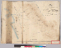
"Map of the county in the vicinity of the Cerrito de San Antonio: Alameda County / surveyed by Jas. T. Stratton, March 1861" <http://content.cdlib.org/ark:/13030/hb6779p0mz/>〔calisphere, University of California という、California Digital Library (CDL) の公共サービス・プロジェクトのページ〕
くわしい説明としては――
Title: Map of the country in the vicinity of the Cerrito de San Antonio : Alameda County / surveyed by Jas. T. Stratton, March 1861
Creator/Contributor: Stratton, James T. United States. District Court (California : Northern District). Land case. 100
Date: 1861
Subject: Rancho San Antonio (Alameda County, Calif.) -- Maps, Manuscript Scale [1:15,840]. 20 chains = 1 in. -- (W 122°16'/N 37°52')
Note: Relief shown by shading and spot heights. 4362 S18 Covers the Rancho San Antonio. From: U.S. District Court. California, Northern District. Land case 100 ND, page 2229; land case map E-227 (Bancroft Library). Vincente Peralta, et al., clmts. Shows drainage, roads, land ownership, etc. Pen-and-ink and watercolor.
Physical Description: 1 ms. map : col. ; 44 x 64 cm.
Language: English
Local Call Number: Land Case Map E-227
Collection: Landcase Maps Collection
Contributing Institution: The Bancroft Library, University of California, Berkeley, CA 94720-6000
しかしこの説明だけでは、なんだかよくわからないですし、この拡大・縮小ができる地図の見方もよくわかりません。とりあえずタイトルの「サン=アントニオ山 (the Cerrito de San Antonio) 付近の郡の地図――アラメダ郡」から、Albany Hill が "the Cerrito de San Antonio" と英語とスペイン語のチャンポンで、さらに地図の中では "Cerrito of San Antonio" とさらにチャンポンになっているのがわかります。
説明を求めて検索していると、 "Friends of Five Creeks" という自然保護のボランティア団体のホームページの地図のページにいきあたりました。 その "Creek Maps" のページには、上のバークレーのバンクロフト図書館の古地図も含めてさまざまな新旧の地図が集められて、リンクが張られています。
上の古地図について、地図が「読める」人による詳しい解説がついています。――
This 1861 map of the Friends of Five Creeks area is one of the most detailed available. It shows the few houses and businesses of the time, as well as the first schoolhouse, beside Schoolhouse Creek. Prominent rocks, willow groves -- even some individual trees in the largely treeless flatlands -- are noted. (この、われらがFriends of Five Creeks エリアの1861年の地図は、入手可能な最も詳細な地図です。当時の数少ない家屋と商売を示し、また、スクールハウス・クリーク沿いの最初の学校も示しています。際立った岩、柳の木立ちが――概して樹木のない平地の個々の木々さえも――注記されています。)
Strawberry Creek, the southernmost creek, is shown as dividing in the flatlands, with a side channel running southwest. Some other early maps also show this feature. Near the creek's mouth, you can see the Indian shell mound beside the willow grove and the starch factory, Berkeley's first industry. (南西方向に分かれる支流をもつ南端のストロベリー・クリークが、平地を分割するかたちで示されています。ほかの初期の地図にも同様の記述があるものがあります。このクリークの河口付近に、インディアンの貝塚と、その横に柳の木立ち、そしてバークレーの最初の産業である澱粉工場が見えます。)
The maps [sic.] shows that Schoolhouse Creek, the unnamed creek between Strawberry and Codornices, flowed into a sausal, or willow marsh, at the head of the tidal slough that flowed north through a large salt marsh, reaching the Bay behind Fleming Point (today's Golden Gate Fields race track). (この地図は、スクールハウス・クリーク、つまりストロベリー・クリークと〔その北の〕コドーニシズ〔Codornices 発音わからんです〕クリークのあいだを流れる名前のついていないクリークが、“sausal” つまり柳の湿地へ流れ込んでいる様子を示していますが、そこは大きな塩の沼沢を北へ流れて、フレミング・ポイントの裏手でサンフランシスコ湾に達する、潮流のある潟の先端です。)
Like other early maps, this one shows that Codornices Creek disappeared as a distinct channel west of today's San Pablo Avenue (the wagon road from Oakland to the Castro's Rancho San Pablo). Marin Creek, north of Codornices, similarly disappeared. The waters presumably filtered through grassland to the salt marsh and slough. Thus the creek channels edging today's University Village -- Codornices Creek and Village Creek -- are largely artifacts created to drain this area, now become living creeks. Codornices even has a large trout population. (他の初期の地図のように、この地図はCodornices クリークがはっきりした水路としては、今日のサンパブロ・アヴェニュー(オークランドからカストロ・ランチョ・サンパブロに至る馬車道)の西で消えていることを示しています。Cordonices クリークの北のマリン・クリークも同様に消えています。水はおそらく草地を抜けて、塩湿地と潟へ通じたのでしょう。こういうわけで、今日のユニヴァーシティー・ヴィレッジの端を流れるクリークの水路は――Cordonices クリークとヴィレッジ・クリークです――この地域の排水をするために主として人為的につくられたものが、ほんとうのクリークになったものです。Cordonices クリークは多数のトラウト(鱒)が棲むまでになっています。)
You can see how a fan of creeks joined Cerrito Creek to wind through another large salt marsh north of the Cerrito de San Antonio, now Albany Hill. The southernmost creek in this fan is today called Middle Creek in Albany. Blackberry and Capistrano Creeks in Berkeley. The waters of Blackberry Creek are piped into the culvert that buries Marin Creek. But the sausal, or willow grove, at the creek's mouth remains -- the only one of all those shown on this map. The creeks north of Cerrito were never formally named. Today, they join Cerrito from pipes at Adams Street, just west of San Pablo Avenue. The southernmost one is the creek that flows from Kensington down through the cemetery and East Bay MUD plant. (扇状にいくつものクリークがセリート・クリークに合流し、セリート・デ・サン=アントニオ、つまり今日のアルバニー・ヒルの北で、別の大きな塩性沼沢に曲がりくねって注いでいるのがわかります。この扇型の南端のクリークは今日アルバニーではミドル・クリークと、そしてバークレーではブラックベリー・クリーク、キャピストラノ・クリークと呼ばれるものです。ブラックベリー・クリークの流水は、マリン・クリークを地下に落としている暗渠にパイプで流れ込んでいます。けれども、クリークの河口のsausal、柳の木立ちは残っています――この地図で示された柳の木立ちのなかで唯一残っているものです。セリート・クリークの北の複数のクリークはちゃんとした名前が付けられたことはかつてありませんでした。今日、サンパブロ・アヴェニューのすぐ西のアダムズ・ストリートで水管によってセリート・クリークに合流しています。南端のクリークは、ケンジントンから流れて墓地を抜けてイースト・ベイのMUDプラントに流れています。)
Note the small summit with a house on it at the north end of the Cerrito de San Antonio. This summit, which no longer exists, may have been a shell mound, blasted off and used for fill. (セリート・デ・サン=アントニオ山の北の端に、一軒の家がある頂があることに注意〔アルバニ山の332フィートと208フィートの双子山的な頂は赤字で示されてますが、それより北西のはずれ、地図のWm [=William] H. Gray という名前のある■のところのことです〕。この頂は現在はありませんが、かつては貝塚であったのが、切り崩されて、盛り土、盛り石に使われたのでしょう。)
Today's Wildcat Creek, on the other side of the hills, is called "Little San Pablo Creek" on this map. Other maps of the time show Wildcat and San Pablo Creeks flowing together in the marshy area near their mouths. (山の反対側の、今日のワイルドキャット・クリークは、この地図では「リトル・サンパブロ・クリーク」と呼ばれています。当時の他の地図ではワイルドキャット・クリークとサンパブロ・クリークが河口近くの湿地帯で合流しているのが示されてます。)
ちょっと適当な訳です。こんなに長いとは思わなかったす。 疲れたす。細部を検証するにはやっぱりUCB所蔵の地図で拡大かな、と思います。
つづく。
アルバニ山の南の住宅の物置のような建物の壁に貼ってあるサイン "To the Mountains"
村の時間――にほんブログ村へ新しいページでまいります。クリックをクリっとひとつよろしくお願いいたします。
お気に入りのリンク集
読んでいるブログ(RSS)

Watch Me Disappear さん
- Mucha-holic / ミュシャ中毒 03/22NEW
- ようこそ!子どもの本の森へ 11/22
- カリフォルニア時間 ホイ 12/24
- r2 08/03
- 小心者の杖日記 01/01
- EL30 04/11
- 不連続な読書日記 12/30
- Knights Templar Vault 09/26
- Critical Life (期限付き) 08/27
- 渡辺由佳里のひとり井戸端会議 04/12
- Frisco Freak 01/13
- 私の闇の奥 10/29
- 荒俣宏のオークション博物誌 05/25
- 窓@Berkeley 04/13
- 本を手に 02/22
- 勝手きままにグルメライフ♪w @時々旅行?!w 02/06
- japonisme 09/22
- traveling with the ghost (旧館 Old) 02/12
- Paint It Green × カリフォルニアGreen便り 09/07
- 村上なら春樹より龍 05/01
QRコード

コメント 0